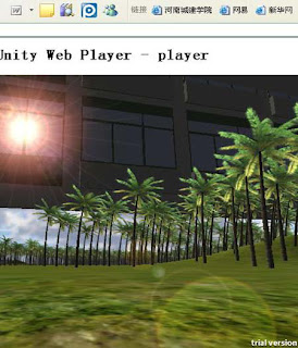
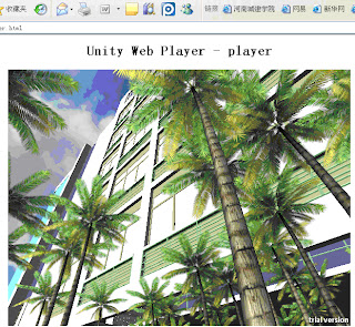
platform for virtual reality. The study area is the campus of
Henan Institute of Urban Construction, Pingdingshan, China,
with an area of 1,066,667m 2, ranging from 33°46′11″N to
33°46′42″N, 113°10′52″E to 113°11′36″E.
FRAMEWORK AND IMPLEMENTATION
A. Framework
Browser-Server three-tier architecture VR-based
framework is designed in the research area and including 3
layers: presentation layer, logic layer and data layer [2].
1) Presentation layer is mainly used for interface display
and to achieve the user's query.
2) Logic layer consists of web server and application
server.
3) Data layer includes the related spatial data and
attribute data, such as DEM data.
B. Implementation
Overall, there are two kinds of works: one is the works
outside unity3D, including models, animations, textures,
sounds and GUI graphics; the other is the works in unity3D,
such as levels, scripts, physics, materials, shaders and GUI.
Figure 2 shows the works outside Unity3D and the works in
unity3D.
III. WORKS OUTSIDE UNITY3D
A. Data Collection
There are two kinds of data we need in the study: spatial
data and attribute data. The data was collected from three
sources:
• The terrain maps which scale is 1:500, obtained by
GPS.
• Two-dimensional maps of the study area including
architectural design maps and design sketch that the
research area previously saved.
• Texture of roads, lawns, trees, public facilities,
buildings taken by camera from different angles.
B. Modeling
The virtual reality environment consists of roads, lights,
traffic symbols, trees, buildings and so on. It is essential to
build fine, sophisticated models of every real object which will
be placed in a virtual field. The precise geographic location,
attribute information and models of geography entities are
needed for achieving good quality objects of scenes.
C. Export
When the modeling is completed, the 3D models are saved
as the format .sbx so as to compatible with Unity3D.
Animations, textures, scripts, and sounds are saved in the asset
file in a Unity3D project; they are
IV. WORKS IN UNITY3D
Unity3D has a highly optimized graphics pipeline for both
DirectX and OpenGL. Animated meshes, particle systems,
advanced lighting and shadows, all run blazing fast. It also
support individual operations for we can create rain, sparks,
dust trails, anything that we can imagine. During the process of
creating a scene, works in Unity3D are as follows:
A. Shading
Unity3D comes with 40 shaders ranging from the simple
(Diffuse, Glossy, etc.) to the very advanced (Self Illuminated
Bumped Specular, etc.) . It achieves a more realistic scenario
results by using the shaders.
B. Programming...
C. Collision Detection ...
D. Showing Information by GUI Control ...
E. Publishing...
Note:
I have not talked about the lines above because I did not found it necessary.
...
F. Others
Sounds, animations, videos will be added in Unity3D by
GameObjects. Thus really enhance the user's immersion in the
virtual reality system [8].
G. Integrating
When all the works above are completed, we save the
scenes, scripts, audios, attribute data, pictures, textures etc. in a
Project in Unity3D.
VI. CONCLUSION
This study generates a virtual reality system based on
Unity3D for taking a campus as an example. The virtual reality
system is highly vivid, strongly interactive. Users can
download a Plug-in to browse the study area online. With a full
range of personalized mode on operation, they can choose their
own way to browse and participate in the virtual reality, and
give full play to their imagination according to their own
wishes without affecting the others by using the designated
keys on the keyboard. The scene keeps on updating 60 times
per second, users will subconsciously input and immediately
immersed in the virtual scene for spontaneous exploration and
observation. It shows that Unity3D not only can serve for game
development, but also can be used in real world. The virtual
reality system can also query information, about the research
area, and do some simple spatial analysis such as illumination
analysis and distance measurement.
In the area of geographic information system, there are
always two methods to get 3D virtual reality, one is to use a 2D
professional platform such as ArcGIS software to get the
virtual reality by secondary development, the other is to use a
3D or 2.5D software as a platform for development, for
example Skyline software.
This is only the preliminary results of our study. The next
step is to Co-GIS software with the system together, so that it
will possess the sophisticated spatial analysis functions of GIS.
This will not only increase the function of the virtual reality
system, but also provide new ideas about the development of
3DGIS.
References:
This paper appears in:
Date of Conference:
18-20 June 2010
Author(s):
Sa Wang
Key Lab. of Resource Environ. & GIS, Capital Normal Univ., Beijing, China


Sem comentários:
Enviar um comentário